Manuscript Tradition in Ptolemy's Geography
Establishing the tradition:
The Geography of Ptolemy presents a great difficulty for scholars of ancient cartography, geography and philology. The history of the text is a problem of scholarly pursuit on par with the information contained within the text itself. An understanding of the tradition of the text is vital if we are to use the contents to its fullest extent. Unfortunately, [1]... scarcely a single existing copy of the work, either in manuscript codex or printed edition, has preserved it free from distortion and confusion.The oldest of these manuscripts was created no earlier than the late thirteenth century[2], over a millennium after the original work was written. Printed editions were not available until 1533. (Latin manuscripts are not the focus of this discussion. However, as a point of reference, it should be noted that there was no Medieval Latin manuscript tradition of the Geography. Latin texts first appeared in the Renaissance, no doubt translated from the Greek manuscripts of the day.) [3]
When trying to establish a manuscript tradition, manuscripts are grouped together into families based upon certain shared characteristics. For the Geography, these characteristics include handwriting, styles of lettering and numbering, errors, and, to a lesser extent, the included (or excluded) maps. For the most part, the maps of the Geography have their own tradition and have little or no bearing on the rest of the text.
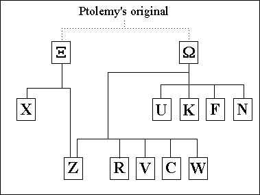
The manuscripts that come down to us today belong to one of two different family trees or recensions. The forty-six extant manuscripts are descendants of one or both of these lines.[4] The forebear of these two branches was not the Ptolemaic original, but a younger manuscript later than Ptolemy. Such a manuscript does not survive today, but must be assumed [2]
...to explain the errors common to all branches of the tradition, which are too numerous and often too serious to be the author's own.The nature of such errors point to a manuscript that utilized capital letters, which were used in manuscripts prior to the ninth century[1]. Miniscule was not utilized until the tenth century, giving us a terminus ante quem. It is possible that this missing link could have been written as far back as late antiquity.[2]
This manuscript, naturally, had its own errors, as well as corrections differentiating it from the original text. Ptolemy had his own original errors, as can be seen from variations between coordinates given in the Geography and Ptolemy's Handy Tables which are not likely to have been produced from scribal copying errors. As more data became available, deliberate attempts at improving the text were also made. As time went on, however, distinguishing between original errors, copying errors, and improvements became more and more difficult.[2]
It is interesting to note that while such a work would seemingly have been a valuable tool throughout its history for the common traveler, pilgrim, merchant, military commander, and ruler, its use in the Middle Ages was minimal, with only a few copies in existence. Such was the case when the oldest of the surviving manuscripts were created at the turn of the fourteenth century. This was a major turning point in the history of the Geography, marking the beginning of a new proliferation of manuscripts.[2]
The probable explanation of this renewed interest in Ptolemy is the work of Byzantine scholar Maximos Planudes (c.1255-1305). Planudes claimed to have
... discovered through many toils the geographia of Ptolemy, which had disappeared for many years.(Kugéas in [2])It is unclear what exactly Planudes "discovered". The text? The maps? Both? In any case, what is clear is that a family of manuscripts was created about 1300 from a single lost copy. [2]
Three of the most important are beautiful large-format parchment codices containing maps. The cost of materials and workmanship must have been enormous, suggesting that these were presentation copies for very wealthy (or imperial) patrons.This family can by identified by the common corrections of errors present in the archetype. Connections can also be drawn via the maps (or lack thereof) that accompany the texts.
While a certain amount of errors in transmission are to be expected (noted as early as the seventh century[1]), emendations have also been made which are not errors, as can be seen by comparing this family to others. In places, the Greek has been corrected or reworded, corruptions from previous traditions have been fixed, and errors in the data possibly dating all the way back to Ptolemy have been adjusted. These alterations seem to have been made due to discrepancies with the text and the maps drawn to the text's specifications.[2] Examples of these discrepancies include cities being plotted in a sea and points along a coastline being plotted in reversed order.
A tree of sources for Ptolemy's Geography
Click on a link below to see more details of the source
| Ξ | Ω | ||||
| X | U | K | F | N | |
| Z | R | V | C | W |
Text vs. Maps:
The text of the Geography and the accompanying maps have two disjoint traditions. It is not unusual to find a manuscript of the text with maps done in a different hand and style or with no maps at all. There are collections of Ptolemaic maps independent of any text save the captions of Book 8.While the rest of the Geography up to Book 8.2, excepting errors and corrections, can be attributed to Ptolemy with some certainty, Ptolemy's authorship of Book 8.29-30 and the world map is doubted, and, in fact, rejected by several scholars. The intervening section of Book 8 containing the regional maps and captions also has been a matter of some debate.[5] Did Ptolemy have a map of the world in front of him, from which he wrote the text? Did Ptolemy create world and/or regional maps based on his text? Or did the maps come later, produced by a student or reader of Ptolemy's text?
Whatever the case may be, in the medieval manuscripts, the maps appear in several distinguishable groups. Firstly, there are the world maps. Very nearly all manuscripts containing any maps, have the world map drawn in the first projection that Ptolemy describes in Book 1 (the great exception being manuscript K, which uses Ptolemy's second projection). Secondly, there are the regional maps. Adopting the scheme of Berggren and Jones, I will denote two classes of manuscripts, and , based on the number of regional maps associated with the manuscripts.[2]
The version of the manuscripts contain twenty-six regional maps which corresponds to the numbers given in the text of the Geography Book 8.2. The maps alternate with their captions found in Book 8. The version contains sixty-four regional maps. These maps are interspersed with the main body of text where the various areas are catalogued. In both versions, the regional maps follow the projection described for them by Ptolemy, namely a cylindrical projection in which distances along the central latitude and longitude are in the proper ratio.[2]
The maps of the version manuscripts, for the most part, derive from the maps in U. The key feature connecting the version is found on the world map. These contain an unknown country to the south of the Indian Ocean. Ptolemy does not give any data or coordinates for such a region. The world maps of the version, nonetheless, have the same, rough northern coastline for this unknown territory.[2] The maps of the version are likely to have derived from those of the version, the difference being the manuscripts had smaller page dimensions. To fit all of the maps into the manuscript, smaller maps were needed, and so the regional maps were divided into more manageable sizes.[2]
Did Ptolemy draw a map or maps to accompany his text? Berggren and Jones reason for the affirmative [2]:
As Ptolemy insists in 1.17, the way to detect and eliminate inconsistencies such as those he detects in [his predecessor] Marinos' writing is to draw a map.However, such maps may only have been preliminary and intermediate sketches to guide the work and weed out errors. It does not necessarily follow that Ptolemy published any maps with the final version of the text. Certainly the way Ptolemy speaks of the construction of maps and globes in Books 1 and 2, leads one to believe he is speaking through experience. Furthermore, if the point of writing the text was to instruct how to draw a world map, surely he must have tried it himself.[2] Fischer takes this view a step further, concluding that Ptolemy in fact published a world map and several of the regional maps. Fischer claims that the notion that Ptolemy only used drafts of maps to aid in the writing process rests on a false rendering of a passage in the text.[4]
Arguments against the publication of maps with the text rest on the sheer practicality of the matter. Neither manuscript version nor could have contained the maps, which must always have occupied large sheets.[1] For the world map to accommodate all of the cities listed in the catalogue, at best it would need to be one by two metres. One metre in height is over three times the average height of papyrus rolls in the second century AD. Most maps of any size were often displayed publicly, painted or affixed to walls, not in manuscripts.[2] Furthermore, the copying of some thirty maps with each manuscript would have been a vast and expensive undertaking.
Further evidence that the maps do not originate with Ptolemy has been put forward by Diller: [1]
The coordinates on the maps attached to Ptolemy's "Geography" have one remarkable peculiarity. Degrees of longitude and latitude are marked in the margins, and the maps themselves are traversed by parallels and meridians; but while the meridians are fixed by the numbers in the margins, just as on modern maps, with one for every five degrees, the parallels are fixed according to the length of the longest day, at intervals of a quarter, half, or whole hour of difference. This anomaly is a vestige of the fact that latitude was early associated with the length of the day. It was inherited by Ptolemy from Eratosthenes, Hipparchus, and Marinus.Whoever drew the maps used Ptolemy's data, but followed the tradition of Ptolemy's predecessors. Why would Ptolemy have gone through the trouble of calculating the coordinates of all his localities in degrees only to use hours later?
As far as the maps accompanying the extant medieval manuscripts are concerned, Fischer asserts that these maps cannot be traced back to Ptolemy as there are discrepancies between the maps and Ptolemy's text.[4] Berggren and Jones point to Maximos Planudes as the mapmaker. The evidence of this lies mainly with a poem found in one of the manuscripts describing Planudes' discovery of Ptolemy. The poem most likely means that Planudes [2]:
... had taken great pains to rediscover the art of map-making set out in the treatise, and that the emperor Andronikos II had encouraged the patriarch of Alexandria, Athanasios II (who was in Constantinople at the time), to assume the patronage of the expensive project of reconstructing the map or maps.As used in the poem and text of the Geography, "geögraphia" means "map", not the work as a whole. When Planudes refers to geögraphia, he is speaking of constructing the maps. Because of the lack of practically of fitting the maps into the relatively small manuscripts before 1300, [2]
Planudes and his assistants therefore probably had no pictorial models, and the success of their enterprise is proof that Ptolemy succeeded in his attempt to encode the map in words and numbers. The copies of the maps in later manuscripts and printed editions of the Geography were reproduced from Planudes' reconstructions.Berggren and Jones go against Fischer here, at least as far as U is concerned. Fischer concludes that the author of that manuscript was not the mapmaker. In fact, the maps of U are not based on the text of U. Was this perhaps because U was made more ornate than its sister manuscripts for its presentation to the emperor?[4]
What is clear is that unless several lost manuscripts predating U and X come to light, we will never fully understand from where the extant manuscripts are derived, or, more importantly, how different today's texts are from Ptolemy's great original work.
References (show)
- Diller, A., Studies in Greek manuscript tradition, Amsterdam :: Hakkert.
- Ptolemy, Ptolemy's geography : an annotated translation of the theoretical chapters / J. Lennart Berggren and Alexander Jones, ed. J.L. Berggren and A. Jones. 2000, Princeton, NJ ; Oxford :: Princeton University Press. xii, 192 p., 8 p. of col. plates : ill. (some col.), maps (some col.).
- Diller, A., Review of Geography of Claudius Ptolemy by Edward Luther Stevenson. Isis 22(2) (1935) 533-539.
- Hyde, W.W., Review of Text und Karten des Ptolemaus by Paul Schnabel. The American Journal of Philology 62(2) (1941) 244-246.
- Diller, A., Review of Text und Karten des Ptolemaus by Paul Schnabel. Classical Philology 35(3) (1940) 333-336.
Written by Daniel Mintz (University of St Andrews)
Last Update October 2007
Last Update October 2007